
Urban SDK arms emergency management with geospatial AI for infrastructure mitigation and emergency response operations.


EMERGENCY MANAGEMENT
Disaster response
powered by AI
Leverage AI, real-time data, and mission logistics automate to mitigate impact, respond, and recover from natural disasters faster.
AI & logistics for faster
emergency response

MITIGATION INSIGHTS
Identify issues, before they are problems
Model disaster impacts of critical infrastructure and primary evacuation routes.

IMPACT DETECTION
Replace outdated, manual processes
Respond faster with real-time video streaming, detection, and map impacted locations.

RESPONSE WORKFLOW
Automate mission routing & reporting
Emergency response mission routing, asset monitoring, and tracking for reimbursement.

ASSET Integration
Integrate aerial and vehicle assets
Integrated asset tracking and data collection across vehicles, helicopters, and UAVs.
CUSTOMER SUCCESS
Emergency response AI to
detect & restore hurricane
ground zero
Urban SDK supported hurricane assessment, logistics and emergency response operations for Hurricane Helene and Hurricane Milton. The largest evacuation in Florida State history
Hurricane impact live streaming, impact detection, and mapping.
Florida Department of Transportation


Natural disaster assessment, logistics and operations
Advanced disaster management solution designed to streamline emergency response operations
Mitigation
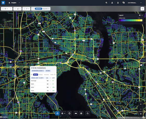
Get daily hourly traffic conditions on every road.

Asset integration & coordination
Refine data by road name, type or specific address using the road class filters.

Mission routing & tracking
Compare current and historic traffic conditions by time of day, day of week, shift or verify complaints.


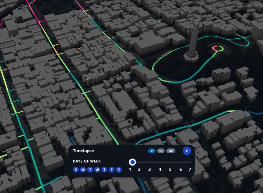
Disaster detection mapping
Data layers provide multiple metrics to compare speeds, volumes, collision index, and speed limits.

Restoration & reimbursement
Select any road segment for a report or filter the entire city to uncover issues.

Plan for hazards, incidents and emergencies
Reduce the loss of life and property by lessening the impact of future disasters.

Data Layer
Emergency digital twin
Enhance disaster response with digital twin analysis to evaluate risk and scenarios from historical event data against current conditions for better response aciton plans.
Urban SDK provides precise hourly speed data to evaluate complaints and deploy resources efficiently for the greatest impact to public safety.
Urban SDK provides precise hourly speed data to evaluate complaints and deploy resources efficiently for the greatest impact to public safety.

Evacuation
Replay historical traffic and forecast evacuation traffic congestion.

Flood Risk
Identify critical areas prone to flooding and property damage.

Plan response and recovery missions
Leverage scenario modeling to create preemptive mission routes for emergency response, utilities and recovery vehicles.
Integrate assets for real-time coordination
Unify response coordination, connectivity, and data across assets, agencies, and public stakeholders.

Data INTEGRATION
Asset Management
Centralized mission planning and coordination across vehicles, helicopters, drone, and UAVs provides operational structure and critical stakeholder execution.
Urban SDK provides precise hourly speed data to evaluate complaints and deploy resources efficiently for the greatest impact to public safety.
Urban SDK provides precise hourly speed data to evaluate complaints and deploy resources efficiently for the greatest impact to public safety.

Connectivity
Integrated connectivity and failover communication

Navigation
Operator mission navigation and location tracking.

Live Streaming & Video Detection
Live stream video and map disaster damage and debris detection.
- Flooding
- Debris
- Property damage
- Vegetation
- Curbside debris
- Road and bridge damage
Validate readiness to respond to hazards, incidents, and emergencies
Develop response mission navigation and training to conduct exercises for response personnel and stakeholders.

Data Layer
Mission Planning
Develop scenario based mission plans to conduct emergency response exercises with new technology.
Urban SDK provides precise hourly speed data to evaluate complaints and deploy resources efficiently for the greatest impact to public safety.
Urban SDK provides precise hourly speed data to evaluate complaints and deploy resources efficiently for the greatest impact to public safety.

Disaster Scenario Modeling
Create customized disaster scenarios based on current local conditions and resources.

Preemptive
Mission Planning
Automate emergency response mission planning to align assets for speed to respond and recover.
Emergency response operations and logistics
Coordination and management of resources utilizing the HALO Incident Command System.

OPERATIONS
Incident Command Center
Supplement emergency management with advanced disaster management solutions to streamline emergency response operations within Departments of Transportation (DOTs), cities, and counties.
Urban SDK provides precise hourly speed data to evaluate complaints and deploy resources efficiently for the greatest impact to public safety.
Urban SDK provides precise hourly speed data to evaluate complaints and deploy resources efficiently for the greatest impact to public safety.

Assets
Integrate vehicles, helicopters, UAV and aircraft in your response.

Missions
Launch pre-planned, simultaneous response missions.
Live Stream & Detection Mapping
Live stream video and leverage AI detection to map impact locations across your entire jurisdiction in less time.
Track asset location, mission progress, and reimbursements
Monitor progress of simultaneous response or recovery mission by asset, missions and results for reimbursement.
Data Layer
Mission Tracking
Integrated mission planning, tracking, and progress automates coordination across multiple assets and stores evidence for reimbursement.
Urban SDK provides precise hourly speed data to evaluate complaints and deploy resources efficiently for the greatest impact to public safety.
Urban SDK provides precise hourly speed data to evaluate complaints and deploy resources efficiently for the greatest impact to public safety.

Live Locations
Track live locations of any response asset.

Mission Progress
Monitor mission schedule and progress to completion.

Mission Reimbursement
Store every mission across any asset to automate evidence reporting and reimbursement.
Recover through a coordinated, timely restoration
Continue beyond the emergency to restore critical community functions and manage the efforts.

Data Layer
Recovery
Organize recovery efforts, schedule recovery tasks, and automate priorities from emergency response incident detection mapping.
Urban SDK provides precise hourly speed data to evaluate complaints and deploy resources efficiently for the greatest impact to public safety.
Urban SDK provides precise hourly speed data to evaluate complaints and deploy resources efficiently for the greatest impact to public safety.
Recovery mission planning
Scale recovery management and reimbursement with emergency and post-emergency data collection from satellite and aerial assets.
- Debris
- Road damage
- Curbside Debris
- Standing water
- Property damage
- Vegetation
- Commercial property
- Transportation assets
Watch Demo
Hourly traffic speed data and metrics from vehicle telematic and GPS data sources on all your roads.

PREVIEW DEMO
EXPERIENCE OUR PLATFORM
View traffic data and analytics to replace manual data collection,
save your staff time, and overcome budget shortfall.

Traffic Calming
VALIDATE SAFETY IMPROVEMENTS
Explore our traffic calming solution providing speed, volume, and collision risk on every road in your community.

Traffic Enforcement
Target speeding hotspots
Explore our traffic enforcement solution providing speeding and collision risk hotspots to assign patrol by time of day.

Traffic Delay
monitor commuting & Traffic Signals
Explore our traffic delay solution to monitor travel time, traffic signal timing, and critical commuting corridors.
Traffic Calming
Explore our traffic calming solution providing speed, volume, and collision risk on every road in your community.
Traffic Enforcement
Explore our traffic enforcement solution providing speeding and collision risk hotspots to assign patrol by time of day.
Travel Delay
Explore our traffic delay solution to monitor travel time, traffic signal timing, and critical commuting corridors.
RETURN ON INVESTMENT
Join 200+ Communities in North America enabled by AI
Urban SDK provides precise hourly speed data to evaluate complaints and deploy resources efficiently for the greatest impact to public safety.
Urban SDK provides precise hourly speed data to evaluate complaints and deploy resources efficiently for the greatest impact to public safety.

Save Time
Replace manual tasks, outsourced analysis, and expensive hardware with data and AI.

Improve Safety
Identify lurking traffic safety, infrastructure conditions, and natural disaster risks.

Respond Faster
Respond to citizen complaints and clear your backlog sooner with fewer resources.

Report Progress
Generate custom reports, share data, and automate public complaints task work in just a few clicks.
Get 30 days of speeding, traffic volume and collision indexing in your city.


Customer success across
hundreds of cities
See how geospatial ai is empowering proactive public safety in large and small communities.
Urban SDK Raises $65M Growth Round from Riverwood Capital to Scale AI-Powered System of Action for Local Governments, Transforming Public Safety and Service
Funding Accelerates Expansion of Geospatial AI Technology, Helping Cities Efficiently Respond to Critical Safety Concerns
Urban SDK Raises $65M Growth Round from Riverwood Capital to Scale AI-Powered System of Action for Local Governments, Transforming Public Safety and Service
Funding Accelerates Expansion of Geospatial AI Technology, Helping Cities Efficiently Respond to Critical Safety Concerns
Traffic Volumes
Building Internal Traffic Analysis Capacity: A Roadmap for Reducing Consultant Reliance
Cities cut consultant reliance with mobility data to validate traffic calming, stop-control requests, and speed concerns using Urban SDK.
Traffic Volumes
Building Internal Traffic Analysis Capacity: A Roadmap for Reducing Consultant Reliance
Cities cut consultant reliance with mobility data to validate traffic calming, stop-control requests, and speed concerns using Urban SDK.
Traffic Volumes
How Cities Can Use Traffic Volume Variability to Evaluate Stop-Control Warrants
Cities use traffic volume and continuous data to assess stop-control warrants, prioritize requests, and make decisions with Urban SDK.
Traffic Volumes
How Cities Can Use Traffic Volume Variability to Evaluate Stop-Control Warrants
Cities use traffic volume and continuous data to assess stop-control warrants, prioritize requests, and make decisions with Urban SDK.
WEBINAR
Identify speeding and proactively enforce issues
See just how quick and easy it is to identify speeding, address complaints, and deploy officers.
