
Disaster Response & Emergency Ops powered by AI
Urban SDK protects your city from natural disasters across every road with AI. Arm emergency management with geospatial AI for mitigation, preparation, response, and recovery.


EMERGENCY MANAGEMENT
Incident management
powered by AI
Leverage AI, real-time data, and mission logistics automate to mitigate impact, respond, and recover from natural disasters faster.
Mission areas &
core capabilities

MITIGATION INSIGHTS
Identify issues, before they are problems
Model disaster impacts of critical infrastructure and primary evacuation routes.

IMPACT DETECTION
Replace outdated, manual processes
Respond faster with real-time video streaming, detection, and map impacted locations.

RESPONSE WORKFLOW
Automate mission routing & reporting
Emergency response mission routing, asset monitoring, and tracking for reimbursement.

ASSET Integration
Integrate aerial and vehicle assets
Integrated asset tracking and data collection across vehicles, helicopters, and UAVs.
Plan for hazards, incidents and emergencies
Reduce the loss of life and property by lessening the impact of future disasters.

Data Layer
Emergency digital twin
Enhance disaster response with digital twin analysis to evaluate risk and scenarios from historical event data against current conditions for better response aciton plans.
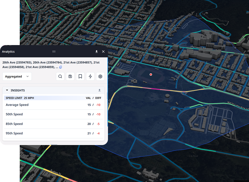
Urban SDK provides precise hourly speed data to evaluate complaints and deploy resources efficiently for the greatest impact to public safety.
Urban SDK provides precise hourly speed data to evaluate complaints and deploy resources efficiently for the greatest impact to public safety.

Evacuation
Replay historical traffic and forecast evacuation traffic congestion.

Roads & drainage
Identify critical areas prone to flooding and property damage.

Plan response and recovery missions
Leverage scenario modeling to create preemptive mission routes for emergency response, utilities and recovery vehicles.
Integrate assets for real-time coordination from the field
Unify response coordination, field connectivity, and data across assets, missions, agencies, and public stakeholders.

Data INTEGRATION
Field Asset Management
Centralized mission planning and coordination across vehicles, helicopters, drone, and UAVs provides operational structure and critical stakeholder execution.
Urban SDK provides precise hourly speed data to evaluate complaints and deploy resources efficiently for the greatest impact to public safety.
Urban SDK provides precise hourly speed data to evaluate complaints and deploy resources efficiently for the greatest impact to public safety.

Connectivity
Integrated connectivity and failover communication

Navigation
Operator canvas mission navigation and location tracking.

Live Streaming & Video Detection
Live stream video and map disaster damage and debris detection.
- Flooding
- Debris
- Property damage
- Vegetation
- Curbside debris
- Road and bridge damage
Automate mission planning to respond to hazards, incidents, and emergencies
Replace outdated, manual GIS mapping with canvas mission planning, real-time data, and navigation.

Data Layer
Mission Planning
Replace static, outdated GIS maps with scenario based mission plans to conduct emergency response exercises with new technology.
Urban SDK provides precise hourly speed data to evaluate complaints and deploy resources efficiently for the greatest impact to public safety.
Urban SDK provides precise hourly speed data to evaluate complaints and deploy resources efficiently for the greatest impact to public safety.

Disaster Scenario Modeling
Create customized disaster scenarios based on current local conditions and resources.

Preemptive
Mission Planning
Automate emergency response mission planning to align assets for speed to respond and recover.
AI enabled emergency response operations and logistics
Activate a real-time streaming and AI detection to coordinate field resources,
operate simultaneous missions, and automate reporting.

OPERATIONS
Incident Command Center
Supplement emergency management with advanced disaster management solutions to streamline emergency response operations within Departments of Transportation (DOTs), cities, and counties.
Urban SDK provides precise hourly speed data to evaluate complaints and deploy resources efficiently for the greatest impact to public safety.
Urban SDK provides precise hourly speed data to evaluate complaints and deploy resources efficiently for the greatest impact to public safety.

Assets
Integrate vehicles, helicopters, UAV and aircraft in your response.

Missions
Launch pre-planned, simultaneous response missions.
Live Stream & Detection Mapping
Live stream video and leverage AI detection to map impact locations across your entire jurisdiction in less time.
Track asset location, mission progress, and reimbursements
Monitor progress of canvas response or recovery missions by asset, missions and results for reimbursement.
Data Layer
Mission Tracking
Integrated mission planning, tracking, and progress automates coordination across multiple assets and stores evidence for reimbursement.
Urban SDK provides precise hourly speed data to evaluate complaints and deploy resources efficiently for the greatest impact to public safety.
Urban SDK provides precise hourly speed data to evaluate complaints and deploy resources efficiently for the greatest impact to public safety.

Live Locations
Track live locations of any response asset.

Mission Progress
Monitor mission schedule and progress to completion.

Mission Reimbursement
Store every mission across any asset to automate evidence reporting and reimbursement.
Recover through a coordinated, timely restoration
Continue beyond the emergency to restore critical community functions and manage the efforts.

Data Layer
Recovery
Organize recovery efforts, schedule recovery tasks, and automate priorities from emergency response incident detection mapping.
Urban SDK provides precise hourly speed data to evaluate complaints and deploy resources efficiently for the greatest impact to public safety.
Urban SDK provides precise hourly speed data to evaluate complaints and deploy resources efficiently for the greatest impact to public safety.
Recovery mission planning
Scale recovery management and reimbursement with emergency and post-emergency data collection from satellite and aerial assets.
- Debris
- Road damage
- Curbside Debris
- Standing water
- Property damage
- Vegetation
- Commercial property
- Transportation assets
CUSTOMER SUCCESS
Emergency response AI to
detect & restore hurricane
ground zero
Urban SDK supported hurricane assessment, logistics and emergency response operations for Hurricane Helene and Hurricane Milton. The largest evacuation in Florida State history
Hurricane impact live streaming, impact detection, and mapping.
Florida Department of Transportation


Urban SDK provides precise speed and volume data to evaluate complaints and deploy traffic calming resources to improve public safety.
Urban SDK provides precise speed and volume data to evaluate complaints and deploy traffic calming resources to improve public safety.

Manage Public Complaints
Agencies can respond to complaints within 5 minutes, eliminating the need to collect data on streets with perception-based issues.

Pre & Post Implementation
Agencies can monitor and analyze the impact of construction and countermeasures to report resource or project effectiveness.

Proactive Safety Measures
Empower your staff with daily road data to identify, enforce and apply countermeasures to dangerous areas.

Reporting and Communication
Automate PDF reports to provide officials and constituents with clear, reports to document community progress.
WEBINAR
Identify speeding and proactively enforce issues
See just how quick and easy it is to identify speeding, address complaints, and deploy officers.
